Longmont, Colorado Area Guide
Living in Longmont, Colorado: Where Should You Start Looking?
Longmont gets easier to understand once you learn three local reference points:
Main Street. Hover Street. The Diagonal.
Main Street is US 287 and runs through Downtown. Hover is the other north-south road you quickly learn when comparing west Longmont. CO 119—the road between Longmont and Boulder that people commonly call the Diagonal—cuts across the south side and becomes especially important when Boulder is part of your regular week. CDOT is currently rebuilding that corridor with transportation and bikeway improvements, so the way it works is still changing.
Once those roads make sense, the housing map starts to make sense too.
Near Downtown you have Old Town and the Historic Eastside, with older houses, alleys, mature blocks, and Longmont's historic street grid.
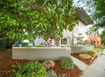
South of the older city, Prospect gives you something completely different: a deliberately compact New Urbanist neighborhood with mixed housing and commercial uses.
Move southwest past Hover and you encounter Renaissance, Somerset Meadows, West Grange, and newer development where Clover Basin, Airport Road, parks, and future buildout matter more.
Go northeast and Spring Valley at Ute Creek creates another version of Longmont around Ute Creek Golf Course, 17th Avenue, Pace Street, and the east-side trail network.
Start with Longmont homes for sale, then use this guide to decide which part of the city deserves your attention.
Four Useful Ways to Begin a Longmont Home Search
Old Town & Historic Longmont
Downtown, Historic Eastside, older houses, alleys, Main Street, Roosevelt Park, and blocks where architecture and renovation history matter.
Prospect & South Longmont
A compact New Urbanist community south of the original city with narrow streets, mixed housing, businesses, and a deliberately different neighborhood plan.
Southwest Longmont
Renaissance, Somerset Meadows, West Grange, Clover Basin, Airport Road, and newer residential development west of the older city.
Northeast Longmont & Ute Creek
Spring Valley, Ute Creek Golf Course, 17th Avenue, Pace Street, and a different relationship with east-side Longmont.
These are practical search areas, not official neighborhood boundaries.
Start Downtown if the Longmont in Your Head Is Main Street
Longmont has a real historic center.
Downtown sits along Main Street, with the Historic Eastside and Westside neighborhoods immediately around it. The City recognizes both as National Historic Districts: the Eastside Historic District is generally between Fourth and Eighth Avenues from Kimbark to Atwood Streets, while the Westside Historic District is generally between Third and Fifth Avenues from Terry to Grant Streets.
That is much more useful than saying Longmont has “older-home character.”
If being close to Downtown is important, start with Old Town homes and Historic East Side homes.
Then walk the particular address.
Which side of Main are you on?
How many blocks is the house from the businesses you expect to use?
Does the property use an alley?
Where is the garage?
Do you cross Main Street during your ordinary trip?
And how close is the railroad?
Those are the details that make two central Longmont homes live differently.
For the official historic context, Longmont's Historic Preservation program and Historic Eastside architectural survey are worth using once an older property becomes serious.
“Old Town” and “Historic District” Are Not the Same Thing
This distinction is worth understanding early.
Old Town is a useful real-estate search for older central Longmont.
The City's historic districts have specific mapped boundaries.
So an older house near Downtown is not automatically inside the Historic Eastside or Westside district, and being marketed as “Old Town” does not establish historic status.
That matters mainly when you begin thinking about exterior changes to a specific property.
Use the search label to find the house.
Use City records to determine whether the house itself is designated or falls inside a recognized district. Longmont has three National Historic Districts and more than 130 individually designated local landmarks.
Roosevelt Park Is a Better Central-Longmont Reference Point Than a Generic “Downtown Radius”
Just west of Main Street is Roosevelt Park, one of the city-center landmarks that helps orient the older part of Longmont. City planning material specifically identifies it as a central downtown park immediately adjacent to Downtown.
If an Old Town home catches your attention, use Roosevelt Park, Main Street, and the library/downtown blocks as real reference points.
Walk from the property instead of relying on a listing's “minutes from downtown” language.
The difference between four pleasant residential blocks and a route that repeatedly crosses a major road matters more than the straight-line distance.
Longmont's Railroad Is Something to Understand Before Buying Near It
This is one of the more important hyper-local issues around central Longmont right now.
The BNSF rail line crosses the city at multiple streets, and Longmont is in the middle of a multi-year railroad quiet-zone project.
As of 2026, the work is not complete citywide. The City expects different crossings to enter quiet-zone status at different times through 2028. Current schedules include work at crossings such as 17th, 3rd, 4th, 6th, 9th, Longs Peak, Main, Coffman, Mountain View, Highway 66, and Hover.
That creates a very simple buyer rule:
If a house is close enough to the tracks that train horns matter to you, check the exact crossing and current project status.
Do not assume that “Longmont is getting quiet zones” means the crossing beside the house is already one.
The City's Railroad Quiet Zones page is the authority to use for the current schedule.
Prospect Is Not Just Another Longmont Subdivision
Prospect deserves its own section because the neighborhood plan is genuinely different.
Prospect New Town was developed on a former 80-acre tree farm as a New Urbanist community. Its plan emphasizes narrower streets, mixed residential types, parks, businesses, and offices rather than separating every use into a conventional suburban pattern.
You can see the difference before you ever enter a house.
Buildings sit closer to the street.
Garages and parking are handled differently than in many conventional subdivisions.
Housing forms vary within a compact area.
Commercial uses are integrated into the neighborhood.
If Prospect appeals to you, do not compare it with another Longmont home only on square footage and price.
Walk the blocks.
Look at private outdoor space.
Find the parking that belongs to the property.
See how deliveries, guests, trash, and garage access work.
Determine which association or property documents apply to the individual home.
And decide whether the compact pattern is actually the reason you like it.
The Prospect New Town site is helpful for understanding the community plan before comparing current properties.
Main Street and Hover Street Create Two Different Everyday Maps
Longmont is not literally divided into “Main Street people” and “Hover Street people.”
But those two roads become useful shorthand very quickly.
Main Street gives you the historic commercial spine and direct north-south travel through the older city.
Hover becomes increasingly important as the home search moves west. It connects established west Longmont with Nelson Road, the CO 119/Diagonal corridor, shopping, recreation, and roads leading toward newer southwest communities.
The intersection of Hover and CO 119 is also part of the current CO 119 transportation project, with construction active in 2026.
That is why I would not evaluate a west Longmont house using a generic “distance to Downtown” number.
Run your actual routes.
If Boulder matters, how do you get to the Diagonal?
If Downtown matters, how often do you cross Hover or Main?
If most of your week stays in Longmont, which commercial corridor do you actually use?
The right part of Longmont changes with those answers.
The Diagonal Matters When Boulder Is Part of Your Week
CO 119 between Longmont and Boulder is locally important enough that simply calling it “Highway 119” misses part of the orientation.
This is the Diagonal.
CDOT, Boulder County, and RTD are in the middle of the CO 119 Safety, Mobility and Bikeway project between Boulder and Longmont. Construction began in 2024 and is scheduled into 2027, with roadway changes, a commuter bikeway, and Bus Rapid Transit infrastructure among the project components.
That means old commute assumptions are particularly unhelpful right now.
If Boulder is a regular destination, test the complete trip from representative Longmont homes.
A southwest Longmont property may connect with CO 119 differently from Old Town or northeast Longmont.
And because construction is ongoing, use CDOT's current CO 119 project information rather than relying on an old route description.
Southwest Longmont Is More Than “Newer Houses West of Hover”
The southwest side deserves a more precise explanation.
This is where searches such as Renaissance, Somerset Meadows, and West Grange enter the comparison.
Here, roads such as Clover Basin Drive, Airport Road, Nelson Road, Pike Road, and Hover Street become increasingly useful.
The housing tends to belong to later phases of Longmont's growth than the Historic Eastside or Old Town.
But these communities should not be collapsed into one generic “newer west Longmont” description.
The useful comparison is what exists around each address today, how you reach your repeated roads, and how much nearby development remains unfinished.
Somerset Meadows Has a New Local Park You Can Actually Test
Somerset Meadows has a useful physical reference point in Clover Meadows Park.
The City completed the 6.84-acre park in 2024 at 4850 Heatherhill Street. Longmont identifies Somerset Meadows among the surrounding neighborhoods. The park includes the City's first bike playground, an accessible playground, field space, and a city-owned apple orchard.
That gives you something concrete to evaluate from a listing.
If park access is part of the appeal, go from the house to Clover Meadows Park.
See whether the route is actually convenient from that block.
Do not convert “community near a park” into a property feature without making the connection yourself.
The City's Clover Meadows Park page has the current facility information.
West Grange Is a Place to Separate Today's Amenities From Tomorrow's Plans
West Grange is especially useful for buyers considering newer southwest Longmont.
It is also a good example of why future amenities need careful wording.
Longmont's current parks tracking still identifies a West Grange neighborhood park as an unfinished system item. The City also states that a future park west of Mountain Drive has not yet been master planned or designed.
So if a West Grange listing or sales conversation refers to future park space, separate three things:
What exists now.
What has been formally planned.
What is still conceptual.
The City's Dry Creek Community Park information is useful when nearby future recreation plans affect your decision.
Renaissance Belongs in the Southwest-Longmont Comparison
Renaissance is another search to use once you know the southwest side is working for you.
The useful comparison here is not a generic list of amenities.
Compare the property with Somerset Meadows and West Grange on the details that actually change your week:
How do you reach Hover?
How often do you use Airport Road or Clover Basin?
How far are the ordinary destinations you expect to use?
What association responsibilities come with the specific home?
And does the home put you closer to established surroundings or to land that is still developing?
That is how the subdivision name becomes useful rather than decorative.
Northeast Longmont Has a Different Street Vocabulary
Go northeast and the roads change again.
Now 17th Avenue, Pace Street, Alpine Street, County Line Road, and Highway 66 become more important than Clover Basin or Airport Road.
That is where Spring Valley at Ute Creek belongs in the guide.
The City's own maintenance and capital-planning material ties Spring Valley to the Rough and Ready corridor and Ute Creek area. Current planning also identifies public improvements adjacent to Ute Creek Golf Course along 17th Avenue.
If this search starts winning, compare it as northeast Longmont, not merely as another planned community.
Your route toward Downtown, Boulder, I-25, or northern Front Range destinations will differ from a southwest Longmont address.
Ute Creek Is a Real Location Anchor
The Spring Valley at Ute Creek search gives you an unusually clear geographic reference: Ute Creek Golf Course.
The course and surrounding greenway infrastructure help organize this part of northeast Longmont in a way a subdivision name alone does not. City capital documents identify portions of 17th Avenue directly adjacent to Ute Creek Golf Course.
If golf-course proximity affects your decision, determine what the individual property actually relates to.
Does it front the course?
Does it simply sit within the broader Ute Creek area?
What lies between the house and the course?
How do you reach 17th Avenue or Pace Street?
A community name does not answer those questions.
The St. Vrain Greenway Is Longmont's East-West Outdoor Spine
Longmont's trail system deserves better than a generic “parks and trails” paragraph.
The St. Vrain Greenway follows the creek across the city and connects a series of distinctive places, including Golden Ponds, Roger's Grove, Izaak Walton, Dickens Farm, and Sandstone Ranch. It also connects with the Left Hand Greenway.
That means the creek corridor can become part of everyday movement through Longmont rather than simply a recreation destination.
But access is block-specific.
If a listing promotes proximity to the St. Vrain Greenway, locate the actual connection from the house.
Can you walk or bike to it without a major detour?
Which street crossing is involved?
Does the nearby path connect to the portion of the greenway you actually expect to use?
The City's St. Vrain Greenway page is the right place to begin.
Longmont Has Its Own Fiber Network
This is a small point, but it is genuinely Longmont.
The City operates NextLight, its community-owned fiber internet system. The network began serving Longmont customers in 2014 and has since expanded beyond some original city limits.
If internet service materially affects your home decision, check the specific address through NextLight rather than treating a Longmont mailing address as proof of service.
It does not need to dominate the area guide.
It is simply one unusually local item worth knowing.
Some Longmont Homes Are in Weld County
Another Longmont-specific boundary deserves one short mention.
The City extends into both Boulder County and Weld County. Longmont's own emergency-notification guidance explicitly addresses residents who live inside Longmont city limits on the Weld County side.
For most buyers, this matters only once a home becomes serious.
At that point, establish the county before pulling county property and tax records.
Do not assume every Longmont city address is a Boulder County parcel.
Longmont's City and GIS Maps provide city-limit and boundary information when you need it.
Compare Longmont Communities Side by Side
Historic East Side
Start here when older architecture, the historic grid, and proximity to Downtown are central to the search.
Old Town
A broader central-Longmont search for older houses and established blocks around the original city.
Prospect
A deliberately compact New Urbanist community where the street plan, mixed uses, parking, and housing forms differ from conventional subdivisions.
Renaissance
A southwest Longmont search where Hover, Airport Road, Clover Basin, and the west-side road network become more relevant.
West Grange
Newer southwest Longmont where existing amenities and future planned improvements should be separated carefully.
Somerset Meadows
A southwest search near Clover Meadows Park and newer residential growth.
Spring Valley at Ute Creek
A northeast Longmont comparison organized around Ute Creek, 17th Avenue, Pace Street, and a different regional travel pattern.
Browse Longmont Homes by Type
Single-Family Homes
Compare detached homes from the historic city grid through established neighborhoods and newer development.
Townhomes
Compare the unit together with association maintenance, parking, insurance responsibilities, exterior rules, and recurring costs.
Condos
Review the unit, association finances, insurance structure, parking, storage, and exterior responsibilities together.
Ranch Homes
Use this to discover ranch-style listings, then verify the individual floor plan and any stairs elsewhere on the property.
New Construction
Especially useful in newer southwest and other active development areas. Look beyond the house at the surrounding parcels and road network.
Land for Sale
Treat land as its own due-diligence search. Access, utilities, zoning, floodplain, development standards, and buildability belong to the individual parcel.
Homes With Basements
Find basement listings, then compare finish, egress, moisture history, permits, and current condition.
Homes With a Main-Floor Primary Bedroom
Useful when bedroom location matters more than the architectural label used in the listing.
Mid-Century Modern Homes
Use the architectural search to surface possibilities, then distinguish genuine design characteristics from a marketing label.
Duplex-Style Homes
Use this to find paired and duplex-style properties while confirming the legal ownership form and shared responsibilities for the individual home.
For broader comparisons among ownership and building types, use Colorado Home Types.
Test Longmont With the Roads Before You Narrow to a Neighborhood
If I were showing Longmont to someone who did not know the city, I would not start with seven subdivision tours.
I would teach the roads.
Start Downtown on Main Street.
Drive through the Historic Eastside.
Head south toward Prospect.
Take CO 119 west toward Hover.
Then drive through the southwest side around Clover Basin and Airport Road.
On another pass, head northeast toward 17th, Pace, and Ute Creek.
That drive makes the city much easier to read.
You begin to understand which part of Longmont gives you the housing pattern you want and which road will become part of your ordinary week.
Then Test the Trips That Actually Matter
Once several homes survive, use the same destinations from every address.
Go Downtown.
Go to the grocery store you would actually use.
If Boulder matters, get onto the Diagonal.
If another Front Range city matters, make that trip.
If the Greenway matters, find the entrance.
If rail noise matters, identify the crossing.
Do not ask which Longmont neighborhood is “best.”
Ask which address repeatedly puts you where you need to go with the home and ownership responsibilities you actually want.
Compare Longmont With Boulder, Erie, Loveland, and Berthoud
Use the Boulder Area Guide when Boulder is not merely an occasional destination but a major part of the location decision.
Use the Erie Area Guide if newer planned development and the CO 7/US 287 side of the region keep pulling your search south.
Use the Loveland Area Guide when your repeated travel runs north and the I-25/Northern Colorado side of the decision is becoming more important.
Use the Berthoud Area Guide when a smaller community farther north competes with Longmont for the same housing search.
Keep the comparison consistent: same housing type, same repeated destinations, same appetite for older-home projects or newer-development obligations.
Keep Exploring Colorado Homes
If Longmont is one part of a larger search, search Colorado homes by area.
You can also compare Colorado home types, use the Front Range Relocation Checklist, or browse all real-estate guides.
Ready to Compare Longmont Homes?
Tell Kenna Real Estate Group which Longmont homes are catching your attention and what you need the location to do for you.
We can help you compare an Old Town or Historic Eastside house with Prospect, Renaissance, Somerset Meadows, West Grange, Spring Valley at Ute Creek, or another Longmont option—and focus the property research on the details that actually change your decision.