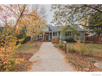
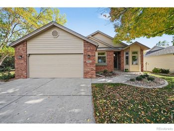
New - 17 Hours Ago

$2,100,000
Active
6
Beds
5
Baths
4402
Sqft
0.22
Acres
608 Peterson St, Fort Collins, CO 80524
MLS#: 4867053
.jpg)



Choosing the right location for a Colorado home means checking nine things before you check the kitchen: the FEMA flood zone, the wildfire risk rating, radon, highway and flight-path noise, what is planned on the vacant land nearby, the county and district mill levy, the water provider, the rush-hour commute in minutes, and the distance to parks and trails. Every one of those is public record, and every one changes either the payment or daily life for as long as you own the house.
The Front Range runs 130 miles from Fort Collins to Pueblo, and the answers differ block by block. A home in Louisville and a home in Broomfield sit 10 minutes apart with different wildfire scores, water providers and tax bills. Buyers new to the state should read the Colorado home buyers guide first.
Colorado floods come from creeks, not rivers on the coast. The South Platte, Cherry Creek, Bear Creek, Clear Creek, Sand Creek, Boulder Creek, the St. Vrain, the Big Thompson and Fountain Creek all have mapped floodplains running through neighborhoods in Denver, Littleton, Englewood, Lakewood, Arvada, Boulder, Longmont, Loveland and Colorado Springs. The September 2013 floods put homes in Boulder County, Lyons, Longmont and the Big Thompson Canyon under water and rewrote several of those maps.
Look the address up on the FEMA Flood Map Service Center at msc.fema.gov. Zone AE or A means a Special Flood Hazard Area and a lender-required flood policy on any federally backed loan; Zone X means minimal risk and an optional, cheaper policy. Denver metro drainage is managed by the Mile High Flood District, whose maps also show local drainage ways the FEMA map misses. The Denver flood zones and drainage guide lists the creeks street by street.
Wildfire is not a mountain-only problem on the Front Range. The Marshall Fire on December 30, 2021 destroyed more than 1,000 homes in Louisville, Superior and unincorporated Boulder County, in grassland suburbs 25 minutes from downtown Denver. Colorado Springs lost more than 300 homes to the Waldo Canyon Fire in 2012 and about 500 in the Black Forest Fire in 2013. The Jefferson County foothills (Evergreen, Conifer, the west edge of Golden and Morrison), Castle Pines, Roxborough, the west side of Colorado Springs and the Boulder County grasslands all carry elevated ratings.
Check the address on the Colorado State Forest Service wildfire risk viewer, then get an insurance quote before your inspection deadline. Carriers price and decline on their own wildfire scores; a home that scores high pays $1,000 to $3,000 more a year or lands in the Colorado FAIR Plan, the state's insurer of last resort. The wildfire score guide for Colorado buyers shows how to pull the score and what mitigation carriers credit.
Radon is a location issue because the whole Front Range sits in the EPA's highest radon zone; the Colorado Department of Public Health and Environment reports that about half of Colorado homes test above the EPA action level of 4.0 picocuries per liter. It is a house issue because two neighbors test differently and the fix goes on the house. Test every home during inspection ($150 to $250 for a professional 48-hour test) and price mitigation at $1,000 to $2,500 as a seller concession. The radon and the Denver home purchase guide covers the test, the disclosure and the negotiation.
Stand in the backyard at 5 PM on a weekday and at 7 AM on a Saturday. The corridors that carry sound into homes are I-25 the full length of the metro, I-70 from Golden through Aurora, US-36 between Westminster and Boulder, C-470 and E-470, I-225 through Aurora, US-285 and Santa Fe Drive through Littleton. A home within 500 feet of any of them without a sound wall hears traffic all day.
The Denver traffic corridors guide maps the loudest stretches and the neighborhoods that sit behind them.
Every city planning department on the Front Range posts active land-use applications on a map. Pull that map for the half mile around the home. A field zoned for multifamily or commercial will be built; a parcel the county holds as open space will not. Read the city's comprehensive plan for the corridor and check whether a road widening or a new interchange sits in the state transportation plan.
Two Colorado-specific checks. First, oil and gas: Weld County, eastern Adams County, Broomfield, Erie and Firestone have active well pads, and the state's Energy and Carbon Management Commission map shows every well and permit. Colorado requires new wells to sit 2,000 feet from homes, but existing pads stay. Second, a new metro district subdivision next door means construction traffic for 3 to 8 years, and the city's growth plan tells you how many phases are left.
Colorado uses one statewide residential assessment rate, so the tax difference between locations is the total mill levy. That levy stacks the county, the city, water and sanitation districts, fire district, library, and any metro district. Totals on the Front Range run from the 60s in parts of El Paso County to above 150 in new metro district subdivisions in Douglas, Adams and Weld counties. On a $600,000 home, 40 mills of difference is real money every month.
| Location type | Typical total mill levy | Examples |
|---|---|---|
| Established city neighborhood, no metro district | 70 to 95 mills | Denver, Lakewood, Arvada, Littleton, Englewood, Wheat Ridge |
| Master-planned community with an HOA and a legacy district | 90 to 120 mills | Highlands Ranch, Central Park, Broomfield's Anthem |
| New metro district subdivision | 110 to 160+ mills | Parts of Parker, Castle Rock, Erie, Commerce City, Brighton, east Aurora |
Every county assessor's parcel page lists the exact levy and each district on it; confirm the number there, not on a listing. The Denver property taxes guide explains the two-year reappraisal cycle and the June protest window, and shows how the same home's bill changes between Centennial, Littleton, Aurora and Greenwood Village.
Water is a location decision in Colorado because the provider is fixed by the address. Denver Water serves Denver and much of the inner ring through distributor districts. Aurora, Thornton, Westminster, Arvada, Broomfield, Colorado Springs (through Colorado Springs Utilities), Fort Collins, Loveland and Greeley run their own systems. Highlands Ranch is served by Centennial Water and Sanitation District, Castle Rock by Castle Rock Water, and Parker by Parker Water and Sanitation. Outside city limits in Douglas, Elbert and Weld counties, many homes run on wells and septic.
The Denver utility providers and costs guide lists the provider for every metro city with typical bills.
Write the commute as minutes at 7:30 AM, not miles. From Highlands Ranch the Denver Tech Center is 15 to 25 minutes and downtown is 35 to 50. From Castle Rock the Tech Center is 25 to 40 minutes. From Arvada downtown is 20 to 35 and Boulder is 30 to 45. From Broomfield Boulder is 20 to 30. Colorado Springs to the Tech Center is 60 to 80 minutes on I-25. RTD light rail changes the answer for Lone Tree, Littleton, Englewood, Lakewood, Golden and Central Park, where a park-and-ride puts downtown at a fixed 25 to 45 minutes regardless of traffic. Drive the route on a weekday before writing an offer.
Trail access is the location feature Colorado buyers use every week. The Cherry Creek Trail runs from Confluence Park in downtown Denver southeast past Cherry Creek State Park. The High Line Canal Trail runs 71 miles from Waterton Canyon through Littleton, Centennial, Greenwood Village, Denver and Aurora. Highlands Ranch has 70 miles of trails; Jefferson County Open Space holds Red Rocks, Mount Falcon and Lair o' the Bear; Boulder's open space rings the city; Colorado Springs has Garden of the Gods and Palmer Park; Fort Collins has Horsetooth Reservoir and the Poudre Trail. Write the criterion as minutes: "trailhead within 10 minutes on foot," and have the agent mark the streets that touch a regional trail on the tour map.
Location sets three lines on the payment: property tax at the parcel's mill levy, homeowners insurance priced on hail plus the wildfire score, and any flood policy. On the same $600,000 loan, a Lakewood home in Zone X with an 80-mill levy and a Castle Pines home with a high wildfire score and a 130-mill levy differ by $300 to $500 a month. Mike Oswald, VP of Mortgage Lending at Rate, NMLS 261003, Equal Housing Lender, runs the payment at the real address for Kenna Real Estate Group buyers before they write. You are free to use any lender. See the financing page, the mortgage pre-approval guide and, for a first purchase, the first-time buyer guide.
Run the nine checks on your top three cities, then read each city's area guide: Lakewood area guide, Castle Rock area guide, Arvada area guide. Then search inside the area that passes: Explore Lakewood, Explore Castle Rock, Explore Broomfield. A Kenna Real Estate Group agent pulls the flood zone, wildfire score, mill levy and water provider for every home on the tour list before the showing; the buyers page describes that process.
The Kenna Real Estate Group, Keller Williams DTC, runs the flood, wildfire, radon, noise, development, tax and water checks on every home a buyer wants to see, and drives the commute with you. Call or text 303-955-4220. A live person answers. Not a robot, not a phone tree. Or start now and search every home for sale in Colorado.
Questions about any home in Colorado? Call or text 303-955-4220. A live person answers.
Only if the FEMA map puts the address in Zone A or AE and the loan is federally backed. Homes in Zone X near Cherry Creek, the South Platte or Bear Creek qualify for an optional low-cost policy worth pricing.
The western edge along the Backcountry Wilderness Area and the ridgelines above Chatfield carry elevated grassland ratings; the interior neighborhoods rate lower. Pull the Colorado State Forest Service score for the exact address and get an insurance quote before the inspection deadline.
Green Valley Ranch, northeast Aurora, Commerce City's Reunion area, Brighton and eastern Thornton sit under the arrival and departure paths. Denver publishes DIA noise contour maps; read them before buying north or east of E-470.
Beyond 500 feet, or behind a sound wall in the first row. Visit at 5 PM on a weekday and at 7 AM on a Saturday, because I-25 and I-70 carry different traffic at each hour.
Not by county rate alone; the difference comes from metro districts. An older Denver neighborhood runs 70 to 95 total mills, while a new Parker or Castle Rock subdivision in a metro district runs 110 to 160. The county assessor's parcel page shows the exact levy.
Open the city or county planning department's active development map and search the half mile around the address. Zoning tells you what is allowed; an active application tells you what is coming.
Yes. A summer bill for a quarter-acre turf lot runs $80 to $150 a month in Denver and $150 to $300 in some south Douglas County districts, and tap fees on new builds in those districts run into the tens of thousands of dollars.